
Wetlands map identifies areas that could be affected by sea level rise
Identifying future wetlands can help guide conservation
ANNAPOLIS – As sea level rise changes the coastal landscape of Maryland in the future some existing wetlands will be submerged, while existing land will become wetlands.
A state mapping …

You must be a member to read this story.
Join our family of readers for as little as $5 per month and support local, unbiased journalism.
Already a member? Log in to continue. Otherwise, follow the link below to join.
Please log in to continue |
Wetlands map identifies areas that could be affected by sea level rise
Identifying future wetlands can help guide conservation
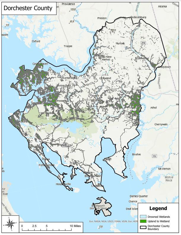
ANNAPOLIS – As sea level rise changes the coastal landscape of Maryland in the future some existing wetlands will be submerged, while existing land will become wetlands.
A state mapping project coordinated by Maryland’s Department of Natural Resources (DNR) provides a look ahead at what areas could become flooded or have potential as beneficial wetlands in the future. The project is intended to help officials prepare for sea level rise and identify areas that need conservation action.
DNR, in collaboration with George Mason University and The Nature Conservancy, ran an updated model to predict the future location and size of wetlands resulting from sea level rise. Using this model, the team also created a data layer that scores coastal areas based on their future potential as wetlands.
“With these greater insights into the future effects of sea level rise, land managers can proactively identify areas that will be key for wildlife conservation while protecting coastal communities from storm impacts and nuisance flooding,” said Sara Coleman, a conservation resilience planner with DNR who is helping roll out the updated wetland migration data. “This data will improve targeting of land acquisitions and easements, particularly on the lower Eastern Shore where the impacts of sea level rise will be most acute.”
The map is available on the Maryland Coastal Atlas, found on DNR’s website. Viewers can select the “Layer List” icon in the center of the top navigation bar, and then choose layers from the “Wetland Adaptation to Sea Level Rise” category. All layers are also visible together on the iMap version.
Wetlands provide a host of benefits to coastal communities, including enhanced water quality, fish and wildlife habitat, recreational opportunities, and protection from flooding and erosion by buffering waves and trapping sediment.
“With the growing impacts of sea level rise, it’s more critical than ever that we protect corridors of land where marshes can successfully migrate and continue to benefit our coastal communities,” said Bob Allen, the Climate and Ecosystem Resiliency Director for the Maryland/District of Columbia Chapter of The Nature Conservancy. “The updated Wetland Adaptation Areas layer will help conservation organizations identify marshes to protect and restore, ensuring that the investments we make now will persist into the future.”
The project, funded by the National Oceanic and Atmospheric Administration, used models to determine the benefits of coastal habitats now and in the future. With these models in addition to field observations, the team looked at how natural shoreline features, such as marshes and seagrass beds, can reduce the heights of waves and the risks of flooding.
The project builds off of the Sea Level Affecting Marshes Model (SLAMM), which was used to predict the future location and size of wetlands based on six future sea level rise scenarios, ranging from 2 to 6.5 feet of sea level rise by 2100. These predicted marsh migration zones, also known as Wetland Adaptation Areas, provide blueprints for conservation action across Maryland.
The new project analyzes the results of SLAMM for specific conservation criteria for long-term planning that may help increase coastal resiliency in Maryland. It also created data layers that visualize areas that will be above water, fully underwater, or wetlands by the years 2050, 2070, and 2100, differentiating between existing wetlands and areas expected to convert to wetlands.
The new data layers prioritize areas based on the soil type and future presence of wetlands, the size of that wetland in 2100, and the location of green infrastructure or other key areas for terrestrial and freshwater biodiversity conservation.
“One of the first steps in preparing for climate change is painting a picture of future habitat conditions,” said Nicole Carlozo, DNR’s section chief for waterfront and resource planning. “The Maryland Department of Natural Resources is excited to contribute to that picture with an update to the state’s Wetland Adaptation Areas.”
This article originally appeared on the DNR’s website, news.maryland.gov/dnr.


