
Weakening Ophelia still poses a risk of coastal flooding and heavy rain in Delaware and other parts of the US
As weekend storm weakens, a new tropical storm — Philippe — is brewing in the Atlantic
This story will be updated
Sep 24, 2023 12:23 PM
After being downgraded from a tropical storm, Ophelia on Sunday still posed a risk of coastal flooding and heavy rains from Washington, D.C. to New York City, with coastal flood warnings remaining in effect for parts of the Mid-Atlantic region, the U.S. National Hurricane Center said.
But as Ophelia weakens, a new tropical storm — Philippe — is brewing in the Atlantic.
At 5 a.m. Sunday, the hurricane center said Ophelia was located about 85 miles (135 kilometers) south of Washington, D.C., with maximum sustained winds of 25 mph (35 kph) and higher gusts. The storm is expected to continue moving north-northeast before turning east on Sunday night, then continue weakening over the next two days.
Meanwhile, Tropical Storm Philippe was 1,155 miles (1,860 kilometers) west of the Cabo Verde Islands, which are off the west coast of Africa. That storm had maximum sustained winds of 45 mph (75 kph).
Even though Ophelia has been downgraded, the center warned Sunday that swells generated by the storm will affect much of the U.S. East Coast through the weekend, likely causing life-threatening surf and rip currents. Ophelia is also expected to produce 1 to 3 inches (2.5 to 7.6 centimeters) of additional rainfall through Sunday night in portions of the Mid-Atlantic to southern New England. Isolated river flooding is also possible in areas of heavier rainfall, the center said.
Some New Jersey shore communities, including Sea Isle City, already experienced flooding Saturday. Thousands remained without power Sunday in New Jersey. NJ.com reported more than 6,000 customers without power Sunday morning in the state, down from a high of 13,000, with more than half of the remaining outages among Jersey Central Power and Light customers in Monmouth County.
National Weather Service forecasters said numerous communities reported coastal flooding; a video posted on the Mount Holly NWS site said many streets were flooded in Brielle, New Jersey during high tide. Some flooding and road closures were reported in coastal communities in Delaware as well. A number of events scheduled in the region and in the Philadelphia area were canceled due to the storm.
The storm came ashore near Emerald Isle, North Carolina, on Saturday morning with near-hurricane-strength winds of 70 mph (113 kph), but winds weakened as the system traveled north, the center said.
Videos from social media showed riverfront communities in the state such as New Bern, Belhaven and Washington experiencing significant flooding. The extent of the damage was not immediately clear.
Even before making landfall, Ophelia proved treacherous enough that five people, including three children, had to be rescued by the Coast Guard on Friday night. They were aboard a 38-foot (12-meter) catamaran anchored in Lookout Bight in Cape Lookout, North Carolina, stuck in choppy water with strong winds.
A few thousand North Carolina homes and businesses remained without electricity across several eastern counties as of Sunday morning, according to poweroutage.us, which tracks utility reports.
"When you have that slow-moving storm with several inches of rain, coupled with a gust that gets to 30, 40 miles per hour, that's enough to bring down a tree or to bring down limbs," Duke Energy spokesperson Jeff Brooks told WTVD-TV on Saturday.
Also on Saturday, Greenville Police posted a video on Facebook of an officer rescuing a small pit bull from flood waters. Police said the dog was tied to a fence and "just inches from drowning" when Officer B. Schultz responded after someone called authorities about the animal. The dog is safe and Animal Protective Services has opened an investigation, police added.
Brian Haines, a spokesperson for the North Carolina Division of Emergency Management, said there were reports of downed trees but no major road closings. As a precaution, swiftwater rescue teams were staged around eastern North Carolina in case rescues were needed, according to the North Carolina Department of Public Safety. One team helped the Beaufort County Sheriff's Office evacuate 15 people from the Twin Lakes Campground, located between the Pamlico River and the Chocowinity Bay, Haines said on Sunday.
At the southern tip of North Carolina's Outer Banks, event organizers planned on Sunday to salvage some of the weekend's long-running Beaufort Pirate Invasion, a multiday event centering on the 1747 Spanish attack on the town. Winds tore down the big tent for a banquet planned for Saturday and several others were damaged or shredded.
The governors of North Carolina, Virginia and Maryland each declared a state of emergency on Friday.
It is not uncommon for one or two tropical storms, or even hurricanes, to develop off the East Coast each year, National Hurricane Center Director Michael Brennan said.
"We're right at the peak of hurricane season. We can basically have storms form anywhere across much of the Atlantic basin," Brennan said in an interview Friday.
Scientists say climate change could result in hurricanes expanding their reach into mid-latitude regions more often, making storms like this month's Hurricane Lee more common.
One study simulated tropical cyclone tracks from pre-industrial times, modern times and a future with higher emissions. It found that hurricanes would track closer to the coasts, including around Boston, New York City and Virginia, and be more likely to form along the Southeast coast.
In some areas where the storm struck Saturday, the impact was modest. Aaron Montgomery, 38, said he noticed a leak in the roof of his family's new home in Williamsburg, Virginia. They were still able to make the hour-long drive for his wife's birthday to Virginia Beach, where he said the surf and wind were strong but the rain had stopped.
"No leak in a roof is insignificant, so it's certainly something we have to deal with Monday morning," he said.
___
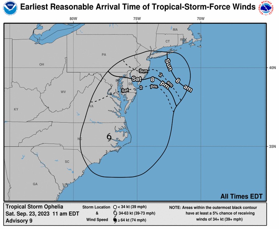
Sep 23, 2023 11:04 AM
ANNAPOLIS, Md. (AP) — Tropical Storm Ophelia swirled across North Carolina after making landfall near Emerald Isle on Saturday morning, lashing eastern parts of the state with rain, damaging winds and dangerous surges of water.
The storm came ashore with near-hurricane-strength winds of 70 mph (110 kph) at around 6:15 a.m. but would keep weakening as it turns north Saturday and then shifts northeast on Sunday, the U.S. National Hurricane Center said.
Ophelia promises a weekend of windy conditions and heavy rain as it churns up the East Coast. Parts of North Carolina and Virginia can expect up to 7 inches of rain (18 centimeters), with 2 to 4 inches (5 to 10 centimeters) forecast in the rest of the mid-Atlantic region through Sunday.
Philippe Papin, a hurricane specialist with the National Hurricane Center, said the primary risk of the storm system over the next couple of days will be the threat of floods from the rain.
"There have been tropical storm-force winds observed, but those are starting to gradually subside as the system moves further inland," Papin said in an interview early Saturday. "However, there is a significant flooding rainfall threat for a large portion of eastern North Carolina into southern Virginia over the next 12 to 24 hours."
Tens of thousands of homes and businesses were left without power across several eastern counties in North Carolina as of Saturday morning, according to poweroutage.us, which tracks utility reports.
"When you have that slow-moving storm with several inches of rain, coupled with a gust that gets to 30, 40 miles per hour, that's enough to bring down a tree or to bring down limbs," Duke Energy spokesperson Jeff Brooks told WTVD-TV on Saturday. "And that's what we've seen in most of the areas where we've experienced outages."
A storm surge warning, indicating danger from rising ocean water pushed inland by Ophelia, was in effect from Bogue Inlet, North Carolina, to Chincoteague, Virginia. Surges between 4 and 6 feet (1.2 and 1.8 meters) were forecast in some areas. A tropical storm warning was issued from Cape Fear, North Carolina, to Fenwick Island, Delaware.
The governors of North Carolina, Virginia and Maryland each declared a state of emergency on Friday. Some schools closed early and several weekend events were canceled. In Washington, the Nationals baseball team postponed its Saturday game until Sunday. The North Carolina Ferry System has suspended service on all routes until conditions improve.
Nancy Shoemaker and her husband Bob stopped to pick up sandbags on Friday in a park in Maryland's capital, Annapolis. A surge of water during a storm last October washed away sandbags they put in their yard, which is right next to the water.
"We're hoping it won't be that way this time," Nancy Shoemaker said. "If we have a lot of wind and a lot of surge, it can look like the ocean out there, so that's a problem."
It is not uncommon for one or two tropical storms, or even hurricanes, to develop right off the East Coast each year, National Hurricane Center Director Michael Brennan said.
"We're right at the peak of hurricane season, we can basically have storms form anywhere across much of the Atlantic basin," Brennan said in an interview Friday.
Scientists say climate change could result in hurricanes expanding their reach into mid-latitude regions more often, making storms like this month's Hurricane Lee more common.
One study simulated tropical cyclone tracks from pre-industrial times, modern times and a future with higher emissions. It found that hurricanes would track closer to the coasts including around Boston, New York and Virginia and be more likely to form along the Southeast coast.
_AP Radio reporter Jackie Quinn in Washington and AP writer Jonathan Mattise in Nashville, Tennessee contributed.
__
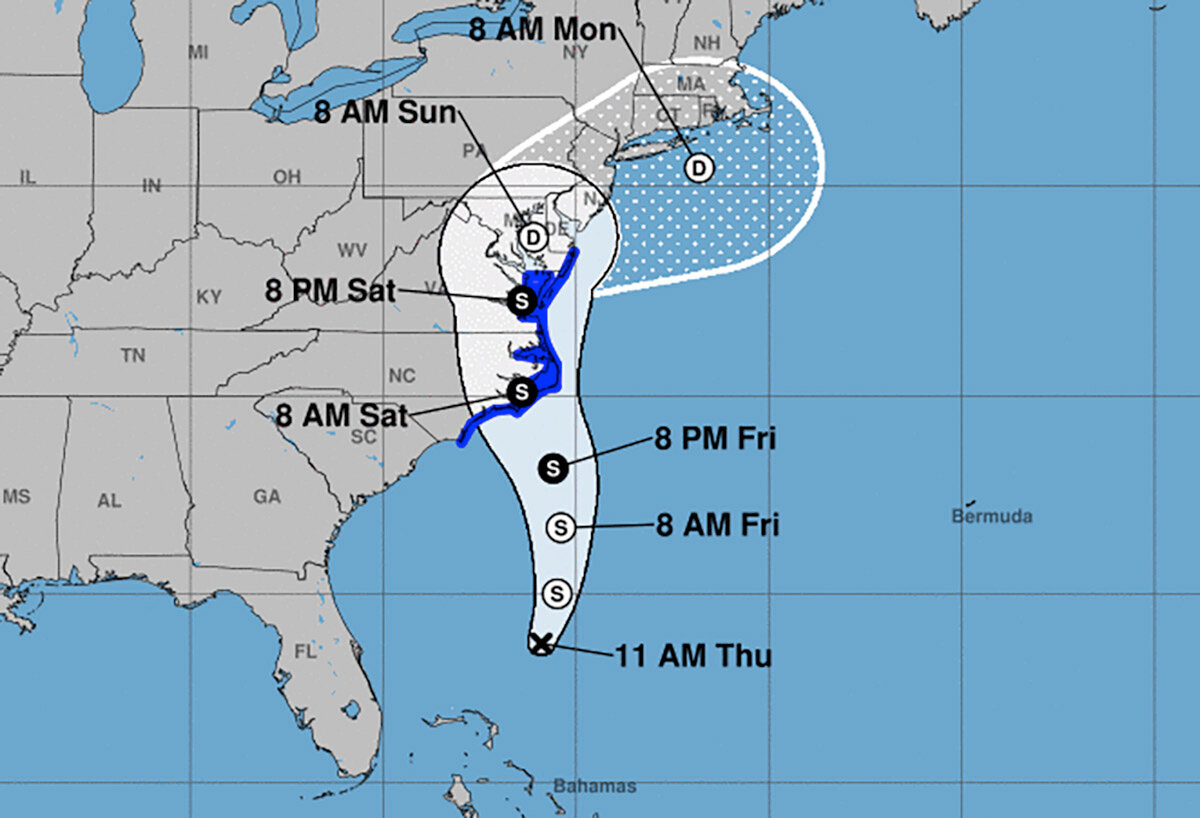
ANNAPOLIS, Md. (AP) — Tropical Storm Ophelia formed off the mid-Atlantic coast and was expected to bring heavy rain, storm surge and windy conditions over the weekend, the National Hurricane Center said Friday.
Ophelia had maximum sustained winds of 60 mph (95 kph), according to a 2 p.m. advisory from the Miami-based center. The storm was centered 150 miles (240 kilometers) southeast of Cape Fear, North Carolina, and was forecast to make landfall Saturday morning.
Virginia's governor declared a state of emergency Friday and the intensifying weather system forced schools to close early and canceled weekend events.
Rain was already moving inland across North Carolina by midday Friday with some areas expected to get up to 7 inches (17.7 centimeters) across eastern parts of the state and into southeast Virginia, forecasters said. Storm surge warning was in effect for some areas, with surges between 3 and 5 feet (0.9 to 1.5 meters) forecast for parts of North Carolina, the hurricane center reported.
The system's center is expected to move inland over eastern North Carolina and southeastern Virginia and near the Chesapeake Bay through Sunday, Mike Brennan, the hurricane center's director, said in a livestreamed briefing on Friday.
A storm surge warning was in effect from Beaufort Inlet, North Carolina, to Chincoteague, Virginia, and a tropical storm warning was issued from Cape Fear, North Carolina to Fenwick Island, Delaware.
Nancy Shoemaker and her husband Bob stopped by a waterside park in downtown Annapolis, Maryland's capital, to pick up sandbags to help protect their waterfront home.
Last year, at the end of October, they experienced a big surge of water that came into their yard and even washed some sandbags away.
"We're hoping it won't be that way this time," Nancy Shoemaker said. "If we have a lot of wind and a lot of surge, it can look like the ocean out there, so that's a problem."
The weather was already affecting water taxis in Annapolis, where water taxi driver Scott Bierman said service would shut down at 6 p.m., and the decision had already been made to close Saturday.
"We don't operate when it's going to endanger passengers and or damage vessels," Bierman said.
Virginia Gov. Glenn Youngkin declared a state of emergency Friday afternoon, issuing an executive order intended to ease response and recovery efforts.
"As this storm has organized and strengthened, it's becoming clear based on the latest forecasts that impacts to the commonwealth are likely," Youngkin said in a statement. "We want to ensure that all communities, particularly those with the greatest anticipated impact, have the resources they need to respond and recover from the effects of this storm."
The governor encouraged residents to prepare an emergency kit and follow the weather forecast closely.
Schools in coastal areas of North Carolina and Virginia announced plans to dismiss students early Friday and cancel afterschool and weekend activities.
The North Carolina Ferry System announced it was suspending several routes and the State Emergency Response Team planned to move to an enhanced watch Friday to ease coordination of resources, the governor's office said.
The forecast prompted the cancellation of events across the region, including the Kunta Kinte Heritage Festival, which had been set to return to City Dock in Annapolis on Saturday.
Meanwhile, Hurricane Nigel was downgraded to a post-tropical cyclone centered about 640 miles (1,030 kilometers) northwest of the Azores with maximum sustained winds of 70 mph (110 kph). There were no associated coastal watches or warnings as the storm moved northeast at 37 mph (59 kph), the hurricane center said in its final update on the system Friday morning.
___
MIAMI (AP) — A storm moving closer to the U.S. East Coast will deliver tropical storm conditions to North Carolina on Friday before making landfall on Saturday, the National Hurricane Center said.
The storm was off the coast of South Carolina and North Carolina with top sustained winds of 50 mph (85 kph). A storm surge watch was in effect, with surges between 3 and 5 feet (0.9 to 1.5 meters) forecast for parts of North Carolina, the center reported.
As of Friday morning, the storm was located about 330 miles (530 kilometers) southeast of Charleston, South Carolina, and about 325 miles (525 kilometers) south Cape Hatteras, North Carolina, and moving north around 14 mph (22 kph), the center said.
Rainfall of 3 to 5 inches (7.6 to 12.7 centimeters), with localized amounts up to 7 inches (17.7 centimeters), was expected across eastern North Carolina and into southeast Virginia through Saturday, the center said.
Though the system had reached tropical storm strength, it was yet to be given a name and the center was still referring to it as Potential Tropical Cyclone Sixteen on Friday morning. The hurricane center defines a potential tropical cyclone as a disturbance posing a threat of tropical storm or hurricane conditions to land within 48 hours.
Meteorologist Maria Torres, a public affairs officer with the Miami-based center, said people along the Atlantic coast need to watch the storm's progress, gather supplies and make preparations for its arrival.
"This will bring some tropical storm force winds and storm surge along with the high winds to the East Coast through the weekend, mainly from the Southeast to the Mid-Atlantic states," she told The Associated Press.
The tropical storm warning was in effect from Cape Fear, North Carolina, to Fenwick Island, Delaware. It also includes the Chesapeake Bay south of North Beach, Tidal Potomac south of Cobb Island and Albemarle and Pamlico Sounds. Storm surge warnings were in effect for areas throughout the region, the hurricane center said.
Virginia emergency management officials warned of heavy rain, high winds and flooding in the next few days.
The Virginia Department of Emergency Management said on social media Thursday that officials are coordinating with local weather service offices to watch the system developing off the coast. Officials called on residents to prepare for the storm and impacts on the region throughout the weekend.
North Carolina Emergency Management warned large swells from distant Hurricane Nigel also would reach the state's coast on Thursday, boosting the rip current risk. The combination of those swells and the low-pressure system could mean additional ocean overwash, beach erosion and coastal flooding.
The hurricane center said storm surge between 2 and 4 feet (0.6 to 1.2 meters) was expected.
A storm surge warning was in effect from Duck, North Carolina, to Chincoteague Virginia, including Chesapeake Bay south of Windmill Point, and for the Neuse River, the Pamlico River, and portions of Pamlico Sound.
A storm surge watch also was issued from Surf City in North Carolina to Duck, North Carolina, along with Chesapeake Bay north of Windmill Point to Smith Point, the Tidal Potomac south of Colonial Beach and Albemarle and the remainder of Pamlico Sound.
Meanwhile, Hurricane Nigel was downgraded to a post-tropical cyclone centered about 640 miles (1,030 kilometers) northwest of the Azores with maximum sustained winds of 70 mph (110 kph). There were no associated coastal watches or warnings as the storm moved northeast at 37 mph (59 kph), the hurricane center said in its final update on the system Friday morning.


