
Horn Point scientists join Cambridge in flood mitigation project
HORN POINT — A research team at the University of Maryland Center for Environmental Science’s (UMCES) Horn Point Laboratory will partner with the City of Cambridge to build and monitor a …

You must be a member to read this story.
Join our family of readers for as little as $5 per month and support local, unbiased journalism.
Already a member? Log in to continue. Otherwise, follow the link below to join.
Please log in to continue |
Horn Point scientists join Cambridge in flood mitigation project
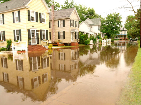
HORN POINT — A research team at the University of Maryland Center for Environmental Science’s (UMCES) Horn Point Laboratory will partner with the City of Cambridge to build and monitor a natural shoreline flood mitigation project along the Choptank River.
"Maryland’s entire eastern shore community is a front-row witness to climate change," UMCES professor Ming Li said in a prepared statement. "The community is already starting to feel the impact of sea level rise. Kids cannot get to school because the streets are flooded, buses can’t get to houses. We are trying to protect the town and also generate new knowledge that will be useful to communities beyond Cambridge, so this project is so extensive, as well as vital."
The city’s Make Cambridge Resilient Flood Mitigation Project, led by Larry White, will stretch from west of city limits, near Gerry Boyle Park at Great Marsh, to the mouth of Cambridge Creek.
Science is informing the design, a statement from UMCES said. Instead of a typical storm-wall, this project will create a hybrid flood barrier along the river that is integrated with a living shoreline – to include oyster reefs, marshes and sediment – that will prevent shoreline erosion, mitigate sea-level rise, improve water quality, enhance ecological development, and reduce wave strength and storm surge.
"You cannot take Isabel as a 100 year storm anymore – it may return every 25-50 years in a changing climate, which changes the risk profile," Li said. "We’re excited to partner with the City of Cambridge and FEMA on this innovative project."
Historically, FEMA’s flood control measures consisted of building infrastructure like levees and walls, so Li said he was thrilled that the federal government recognized the importance of this hybrid approach of incorporating natural-based solutions that are not only ecologically friendly, but esthetically pleasing.
"They listened to the public, to the community that is being affected," said Michael Sieracki, director of the Horn Point Laboratory in Cambridge. "1.6 miles of living shore is huge. You hear a lot about living shorelines, which are gaining traction in the U.S. and abroad, and they’re often associated with single residences, so this project is really large scale, which makes it unique."
According to the Sea-Level Rise Projections for Maryland 2023, Maryland’s shoreline is rising faster than in the past and will likely rise at least a foot, but possibly up to a foot and a half, between 2000 and 2050.
“The size of the rise will ultimately be determined by how much and how soon global society is able to reduce its greenhouse gas emissions,” the statement said. “Society must adapt to sea-level rise over the coming decades, while implementing aggressive steps to limit warming. With its 3,190 miles of shoreline, the state of Maryland is particularly vulnerable to the consequences of sea-level rise.”
Additional project funding will support the improvement of the city’s stormwater management system to include backflow preventers that discharge water to the river to prevent high tides from backing up into the streets and a new system to collect, store and allow the controlled release of stormwater to reduce the risk of flooding.
"The science being done at Horn Point is really cutting edge – we’re good at making these things work, at determining which design aspects for coastal resilience will make this project successful – and we’re located in the city of Cambridge, which will make monitoring the construction and coastal resilience over time easy," said Sieracki.
Additional project team members include William Nardin, Cindy Palinkas, Lorie Staver, and Matthew Gray all of whom are UMCES faculty members, and Xiaohong Wang at Salisbury University.
To optimize the living shore design, Dr. Nardin will conduct modeling analysis to assess the effects of the proposed design on wave attenuation and sediment retention at the project site. Drs. Palinkas and Staver will conduct field sampling and analysis to monitor sediment and vegetation before construction to guide the project design and provide a baseline for evaluation of the performance on the living shoreline after construction; the duo will also conduct a post-construction analysis of the living shoreline to determine the effectiveness of the design. Drs. Li and Wang will conduct a cost/benefit analysis of the project to include assessing coastal flood risks with and without the proposed embankments and living shorelines. Drs. Gray and Nardin will design and configure an oyster reef at the toe of the living shoreline to determine what is best for enhancing fish habitat. The team will also conduct pre- and post-construction evaluations of the water to evaluate the project’s ecological co-benefits.
This is a phased project, spanning three years. FEMA is currently funding Phase I: Design and Permitting and is reserving funding of $16M for Phase II: Construction under the FEMA Hazard Mitigation Assistance Grant. Phase II funding will follow once FEMA reviews and approves the project final design; the review will include the final cost-benefit analysis and ensure the Environmental and Historic Preservation plan complies with environmental regulations.
Phase 1 project activities include data gathering, analysis, detailed design development and permitting required prior to construction. UMCES scientists based at the Horn Point Lab will support the optimization of the living shoreline design and assessment of the hybrid structure's effectiveness in reducing flood risk due to sea level rise combined with coastal storms. The City of Cambridge will coordinate directly with affected property owners for property assessment and concerns.


