
Tropical Storm Debby remnants in Delaware
Tornado watch in effect until 2 p.m. Aug. 9 in Kent, Sussex, New Castle counties
DOVER — Tropical Storm Debby is moving up the east coast, and having already deluged certain areas with more than 10 inches of rain, the state is bracing for expected impacts.
…

You must be a member to read this story.
Join our family of readers for as little as $5 per month and support local, unbiased journalism.
Already a member? Log in to continue. Otherwise, follow the link below to join.
Please log in to continue |
Tropical Storm Debby remnants in Delaware
Tornado watch in effect until 2 p.m. Aug. 9 in Kent, Sussex, New Castle counties
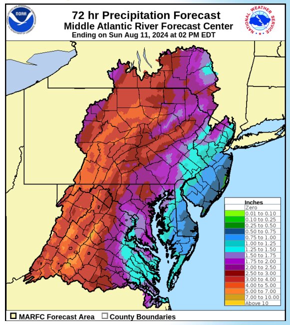

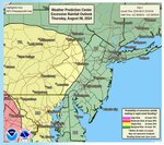
DOVER — The remnants of Tropical Storm Debby continue to move up coast, bringing considerable rain, as the state continues to brace for impacts.
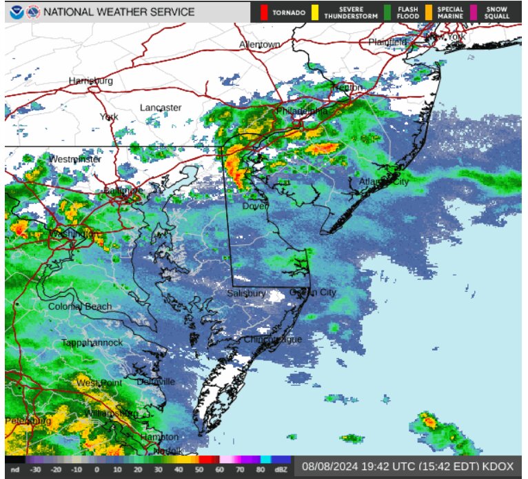
The last comprehensive update, dated 5 p.m. Aug. 8 by the National Weather Service, included a tornado watch for the entire state until 2 p.m. today.
Daily State News staff will update this story with our continued coverage of the storm.
Updated 9:01 EDT Aug. 9 by Brian Gilliland:
Tornado watch issued for Kent, Sussex and New Castle counties until 2 p.m. Friday, Aug. 9.
The following watches and warning remain in effect on Aug. 9:
- Coastal Flood Advisory until August 10, 06:00 AM EDT
- High Surf Advisory in effect from August 9, 08:00 AM EDT until August 9, 08:00 PM EDT
- Wind Advisory in effect from August 9, 06:00 AM EDT until August 9, 11:00 PM EDT
- Tornado Watch in effect from August 9, 06:15 AM EDT until August 9, 02:00 PM EDT
- Rip Current Statement in effect from August 9, 08:00 AM EDT until August 9, 08:00 PM EDT
Updated 15:40 EDT Aug. 8 by Brian Gilliland:
Wind Advisory declared for Kent, inland Sussex, New Castle counties, Delaware beaches
What: South winds 15-25 mph, with gusts up to 50 mph expected.
When: 6 a.m. until 11 p.m. Friday.
Impacts: Frequent 35-45 mph gusts can be expected to blow around unsecured objects. Grounds saturated by the rains, combined with the winds, could bring down trees, the weather service warns. Tree limbs could also fall and a potential for power outages exists.
The weather service suggests securing outdoor objects.
Updated 14:35 EDT by Brian Gilliland:
National Weather Service adds high surf advisory for Delaware Beaches on Friday
What: Waves in excess of five feet in the surf zone from 8 a.m. until 8 p.m. on Friday.
Impacts: Flooding of lots and parks but only isolated road closures expected. Dangerous surfing, swimming and boating conditions persist.
Updated noon EDT by Brian Gilliland:
AAA issues warning about flooded roads
Because a flooded roadway can hide many dangers, AAA issued the following tips to drivers who may encounter flooded roads.
- Turn around: As little as six inches of water can cause drivers to lose control of vehicles and potentially stall engines.
- Never drive through standing water: No matter how shallow it may appear, water may be concealing downed power lines, be deeper than it appears, or have significant force from flooding.
- Slow down: At speeds as low as 35 mph, new tires can still lose some contact with the roadway.
- Increase following distance
- Avoid cruise control
- Brake early
- Be wary of changing wind conditions
- Seek higher ground: If the vehicle stalls or is suddenly caught in rising water, leave it immediately.
Updated 10:30 a.m. EDT by Brian Gilliland:
Gale Warning issued north of Slaughter Bach until Aug. 10
Where: Delaware Bay waters from Slaughter Beach, east of Milford, north to waters near East Point NJ.
What: South and southeast winds 20-30 knots with gusts up to 35 knots along with "very rough waters."
The weather service reccomends altering plans to remain ashore today.
Small Craft Advisory in effect until 6 p.m. Aug. 9
Where: Coastal waters from Cape May, NJ to Cape Henlopen and from Cape Henlopen to Fenwick Island and out 20 nautical miles impacted.
What: In this area, 10 to 20 knot winds with gusts to 25 knots with three to six foot seas are expected.
The weather service reccomends altering plans to remain ashore today.
Updated 10 a.m. EDT by Brian Gilliland:
Coastal Hazard Message issued:
The National Weather Service has issued a warning regarding a high risk of rip currents, which can sweep even the strongest swimmers out to sea, for all Delaware beaches on Aug. 9.
The weather service suggests if caught in a rip current, don’t fight it, but to following the shoreline while signaling for help.


